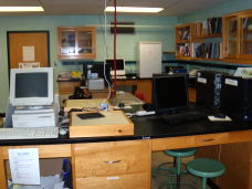
ENVS Computer Lab
The Alfred University computer leasing program ensures that this lab remains current, in terms of hardware and software. Both Mac and Windows platforms are supported.
GPS Capabilities
The Division maintains two sub-meter scale Global Positioning Systems units, and a number of consumer grade GPS units.

Total Station
Field research may require accurate location of sampling sites, etc., and this instrument can be used for this purpose.

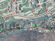
GIS capabilities
The ENVS Division maintains current ESRI licenses for ArcInfo and ArcView, and supports MAPublisher and GRASS on the Mac platform. Courses are offered in GIS on different levels, and many of our other courses incorporate GIS components.
Remote Dataloggers
Data from the Hydrologic Field Station has been collected around the clock for over 15 years by computer controlled dataloggers.

Digitizers, scanners, etc.
To produce effective digital documents, students often use data, images, etc., which are currently available only in hard copy. To facilitate this, the Division has a number of scanners, slide scanners, digitizers, etc.

A separate digital imaging system utilizes scanned images to analyze the growth rings of trees for ecological and climatological analyses. We also have tree ring corers and facilities for preparation of cored tree sections for image analysis.
