OK, this is still a work in progress. Right now I have a dozen or so things I plan to improve, but I figured I'd send it out and see what folks thought about it. It works with some long URL's (view the source and you'll see) so I figured it was easier to start with this page. Click on
this and you should start off with three peaks in the Alfred vicinity. Most things work, although much of the interface is still pretty clunky. At this point there is neither java nor javascript involved, but I see that coming soon, to permit panning the way we're used to, etc.
To understand what we mean by the various peak areas and summits, consider the following picture:
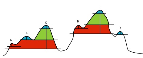
You can see that there is at least 15 m of relief around B, C E and F, but that for A and D, going from left to right across the image, you would not descend 15 m before you began climbing again. Similarly C and E have both 65 and 105 m of relief around them, but the areas covered by the green and red are different.